Wildcat Peak Hike Tilden Park

Peak Pondering

Hiking Wildcat Peak Tilden Regional Park

Some of the most magical hikes begin like a magic trick: The start is filled with lots of people, cute farm animals, and some hustle-bustle frenzy. Then, within minutes, it vanishes! All you have to do is find the entrance to Narnia—or, in this case, Laurel Canyon Trailhead in the East Bay’s Tilden Regional Park.

It’s kind of hidden, but when you do find it, it heralds the start of a 3.5-mile (round-trip) journey featuring a eucalyptus forest, giant sequoias, a lush peace grove, and spectacular views of the bay. The trail winds gently uphill through the woods before leveling briefly at a fire road where you’ll take a hard right to a slinking trail that leads to Wildcat Peak.

On the way, you’ll pass by the Rotary Peace Grove. Established in 1955, the grove commemorates individuals for their contributions to world peace; every year someone is selected to receive the honor. Take a short stroll through the grove’s stocky giant sequoias and view the various plaques naming honorees, including the Dalai Lama.

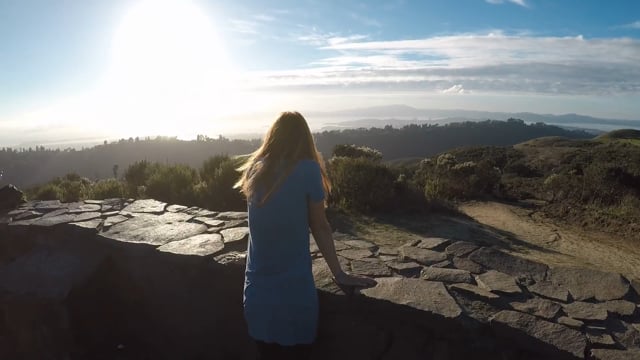
From here it’s a short hike up to Wildcat Peak and its far-reaching panoramic bay views. A beautiful circular stone structure and bench area lead you around the panoramic scenery: The Golden Gate Bridge, San Pablo Reservoir, Mount Diablo, the giant cranes of the Port of Oakland, and the San Francisco skyline all sparkle. You’re just slightly past the halfway point now. From here it’s downhill through the quiet forest before the finale: a peaceful stroll beside Jewel Lake and back to the parking area.

From the Tilden Park visitor center, walk through the back door, across the grass and find the Laurel Canyon Trail. Stay on this all the way to Laurel Canyon Rd. and turn left. From the fire road you’ll make a right turn onto Peak Trail, which is easy to miss (look for the signpost and sharp right singletrack trail going uphill). From here follow Peak Trail to the Rotary Peace Grove and Wildcat Peak. The actual peak is up a short spur trail. Then descend Peak Trail to Sylvan Trail. Turn right on Sylvan Trail, and take Lower Pack Rat Trail along Jewel Lake and back to the visitor center. No dogs.

Trending Stories NorCal

View all Stories
  1. Hiker in the forest at Mount Sutro in San Francisco

    San Francisco's Middle Earth

    No need to travel to New Zealand to visit Middle Earth. San Francisco’s Mount Sutro Open Space is practically Hobbiton—a hidden “shire” in the middle of the city. Okay, maybe not quite as magical, but still an incredible place to take a hike in city limits.

    View
  2. Bikers and walkers on the Bay Area Ridge Trail with the Golden Gate Bridge behind them

    National Park City Walk

    See San Francisco the way locals do by hiking the Presidio, a national park right in the city! Wooded trails, secluded beaches, and epic views of the Golden Gate Bridge feature on this 5.5-mile out-and-back on the Bay Area Ridge Trail. It’s a lovely slice of the City by the Bay.

    View
  3. A group of people clamored around the summit marker at Mission Peak in the Bay Area

    Your Mission Is Less Crowded

    Mission Peak is one of the Bay Area’s most popular mountains, with many hikers climbing every weekend. Skip the crowds with this 6-mile loop up the less-traveled southern route.

    View
  4. Hike top Angel Island Mount Livermore San Francisco Bay

    Good Heavens

    The 4-mile hike to the top of Angel Island offers Bay-mazing scenery. Some people claim you get a five-bridge view: Richmond-San Rafael, Bay, Golden Gate, San Mateo-Hayward, and Dumbarton bridges.

    View

Trending Stories SoCal

View all Stories
  1. Bear Hug

    This 5.5-mile loop through Coyote Lake-Harvey Bear Ranch County Park explores one of the newest segments of the acclaimed Bay Area Ridge Trail, one redolent with trees ranging from madrone and manzanita to buckeye and blue elderberry (with a bubbly post-hike bonus).

    View
  2. Sponsored

    Tram to Cool Treks

    Elevate your fun, getting whisked from palm trees to alpine wilderness on the world’s largest rotating tramcar. The Palm Springs Aerial Tramway transports you up and away on a 2.5-mile scenic route from the desert floor to the refreshing wilderness of Mount San Jacinto State Park.

    View
  3. Coming Up Roses

    Looking to spice up your hiking life? Give your partner a rose—Mount Rose! The 10-mile out-and-back peak hike goes up to one of the grandest views in all of Lake Tahoe. Get ready f

    View
  4. Woman hiking down the stairs to Coast Royale Beach in Orange County

    Secluded Royale

    Panoramic coastal views and a killer leg workout combine on this 2.7-mile (round-trip) out-and-back hike to secluded Coast Royale Beach in Orange County

    View