Keller Hike-in

Hike to Keller Beach in the East Bay Miller Knox Regional Shoreline
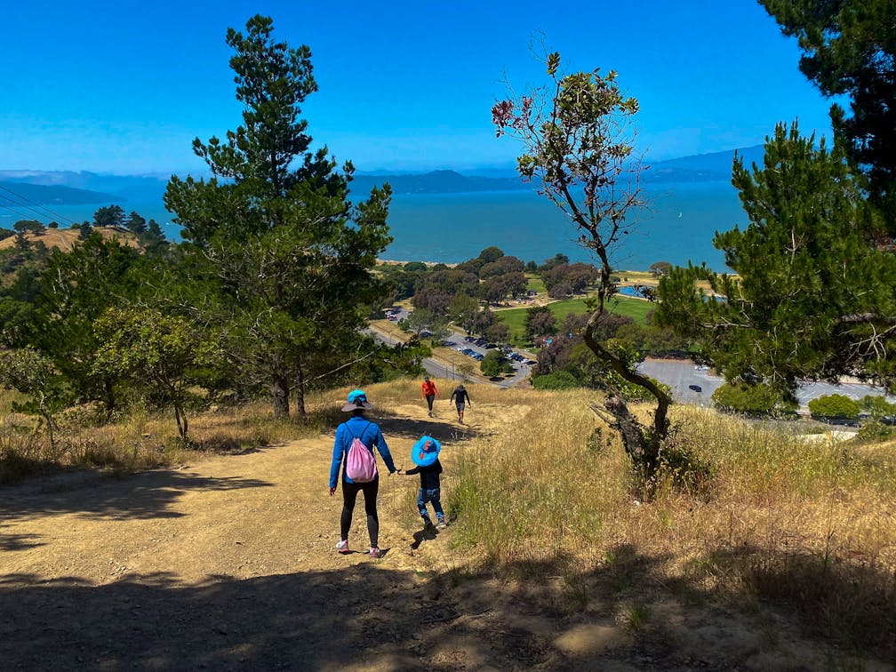
Hikers heading towards Keller Beach in Miller Knox Regional Park East Bay

Hike to a sandy beach on this 3.5-mile adventure through Miller/Knox Regional Shoreline. The coastline views and lingering wildflowers are as refreshing as the beach waves here.

Hiker stopped to pose in front of the stump beach sing at Miller Knox Regional Park in the East Bay

Beach goers at Keller Beach in Miller Knox Regional Park  in the East Bay

From the South Entrance parking lot, cross Dornan Drive to begin the hike up Old Country Road Trail, lined with colorful blooms, from sunny-hued wild mustard to bright purple vetch flowers.

Hiker at Miller Knox Regional Shoreline passing by wildlflowers like lupine

At the intersection, turn right to climb onto West Ridge Point. This vista spot is the southernmost point on the hike and has the best views of San Francisco Bay, including Brickyard Cove, San Francisco, and Oakland.

Woman in a yellow shirt wading in the ocean at Keller Beach in the East Bay

Turn left to head north on the West Ridge Trail. This hilly route is a common workout spot, and thanks to the no-leash allowance in the park, it’s a great place to mingle with the local pups. Violet and white wild radish flowers are currently still in bloom (eagle-eyed hikers may even spot the spicy radish pods!).

Person sitting at a bench overlooking the Golden Gate and Angel Island from Miller Knox Regional Shoreline East Bay

At the dirt traffic circle, take the second exit onto Crest Trail. Keep right on the wooden steps to climb up to the high point of the hike: Nicholl Knob. Snap a selfie with the summit marker, then soak up the spectacular views of Angel Island.

Hiker at Miller Knox Regional Shoreline checking out the Bay Area scenery including Angel Island

Continue downhill on Crest Trail, across Crest Avenue, and onto Old Country Road. Follow signs for the beach and emerge from the woods at Keller Beach Park. Kick off your boots and cool your feet in the water, with a beautiful view of Mount Tamalpais and the Marin Headlands on the horizon.

To head back to the parking lot, follow the coastal hiking path south from the beach until it intersects with the picnic areas at the South Entrance. Before heading home, cross Dornan Drive to visit the Golden State Model Railroad Museum. This museum is one of the oldest model railroad clubs in the country and is on the National Register of Historic Places.

Exterior of the Golden Gate Model Railroad Museum

Inside the Golden Gate Model Railroad Museum

Golden Gate Model Railroad Museum

WINE BONUS: Looking for a glass of vino to end your beach day? Head next door to Riggers Loft for wine tasting right on the bay.

Riggers Loft wine tasting warehouse with people enjoying wine inside

Miller/Knox Regional Shoreline is located at 900 Dornan Dr. in Richmond. From I-580, exit onto Canal Blvd. Turn left onto Garrard Blvd., then continue onto Dornan Dr. into the park. The South Entrance parking lot is on the right side, immediately after passing the Railroad Museum. Park hours are 5 a.m. to 10 p.m. Dogs allowed—no leash required in marked areas. Be mindful of temporary trail closures for restoration areas.

Story and photos by Heather Werner, @heath.er.wer.ner.

Trending Stories NorCal

View all Stories
  1. Hiker in the forest at Mount Sutro in San Francisco

    San Francisco's Middle Earth

    No need to travel to New Zealand to visit Middle Earth. San Francisco’s Mount Sutro Open Space is practically Hobbiton—a hidden “shire” in the middle of the city. Okay, maybe not quite as magical, but still an incredible place to take a hike in city limits.

    View
  2. Bikers and walkers on the Bay Area Ridge Trail with the Golden Gate Bridge behind them

    National Park City Walk

    See San Francisco the way locals do by hiking the Presidio, a national park right in the city! Wooded trails, secluded beaches, and epic views of the Golden Gate Bridge feature on this 5.5-mile out-and-back on the Bay Area Ridge Trail. It’s a lovely slice of the City by the Bay.

    View
  3. A group of people clamored around the summit marker at Mission Peak in the Bay Area

    Your Mission Is Less Crowded

    Mission Peak is one of the Bay Area’s most popular mountains, with many hikers climbing every weekend. Skip the crowds with this 6-mile loop up the less-traveled southern route.

    View
  4. Hike top Angel Island Mount Livermore San Francisco Bay

    Good Heavens

    The 4-mile hike to the top of Angel Island offers Bay-mazing scenery. Some people claim you get a five-bridge view: Richmond-San Rafael, Bay, Golden Gate, San Mateo-Hayward, and Dumbarton bridges.

    View

Trending Stories SoCal

View all Stories
  1. Bear Hug

    This 5.5-mile loop through Coyote Lake-Harvey Bear Ranch County Park explores one of the newest segments of the acclaimed Bay Area Ridge Trail, one redolent with trees ranging from madrone and manzanita to buckeye and blue elderberry (with a bubbly post-hike bonus).

    View
  2. Sponsored

    Tram to Cool Treks

    Elevate your fun, getting whisked from palm trees to alpine wilderness on the world’s largest rotating tramcar. The Palm Springs Aerial Tramway transports you up and away on a 2.5-mile scenic route from the desert floor to the refreshing wilderness of Mount San Jacinto State Park.

    View
  3. Coming Up Roses

    Looking to spice up your hiking life? Give your partner a rose—Mount Rose! The 10-mile out-and-back peak hike goes up to one of the grandest views in all of Lake Tahoe. Get ready f

    View
  4. Woman hiking down the stairs to Coast Royale Beach in Orange County

    Secluded Royale

    Panoramic coastal views and a killer leg workout combine on this 2.7-mile (round-trip) out-and-back hike to secluded Coast Royale Beach in Orange County

    View