Headlands Over Heels
Hike the SCA Trail in the Marin Headlands for Fresh Views of the Golden Gate Bridge


People come from all over the world to get a glimpse of the Golden Gate Bridge. And those vista points get absolutely packed. Get a dramatic and novel view of the bridge without all the people on this moderate 6-mile hike in the Marin Headlands. The SCA Trail is the highlight: a ridge rambling route with panoramas galore of the entire bay and out to the Marin Headlands’ Gerbode and Rodeo valleys (the lesser-known but equally rewarding neighbors of Tennessee Valley).


Warm up your legs on the first stretch before beginning a steady ascent on a wide trail overlooking the green valley below. As you get higher, you’ll gain views of the Pacific. And keep an eye out for freshly blooming wildflowers like shooting stars, lupine, baby blue eyes, popcorn, and of course—California poppies.


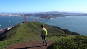
The SCA Trail is the marquee section, a lean trail with southern views towards the towers of the Golden Gate, with panoramas of the ocean. There’s a popular hill detour that leads up to a summit overlooking the bay and Cavallo Point below … some may think this is the famous Slacker Ridge but it’s not (Slacker is marked at a trailhead). Nonetheless it’s a brief and worthy detour before continuing on the SCA to Slacker Trail, where you’ll get to a marked detour up the short and somewhat steep Slacker Ridge. Don’t skip it.

The views from the spacious summit are spectacular, and this is a prime spot for a picnic. The panorama includes Angel Island, Alcatraz, sailboats galore, the San Francisco skyline, and the Golden Gate Bridge. This is a vantage less visited, so soak it in! Then return back to the main trail and follow it to Julian Trail, where you’ll descend into the valley as red-tailed hawks soar above. Close to the end you pass a wide grassy series of fields, the Historic Rifle Range (no longer in use).

Sunset Bonus: Nearby Muir Beach is busy, but later in the day you can usually find some parking. Head out to the beach for some Spikeball or sand dancing, or just lounging and waiting for sunset, which is glorious here.


Park at the Gerbode Valley Parking Lot (map) and start on Rodeo Valley Trail, following signs to the SCA Trail, followed by Slacker Trail, Slacker Ridge, and descending via Julian Trail. No dogs.







