National Park City Walk

Hike the Ridge Trail in Presidio National Park for Classic San Francisco Views
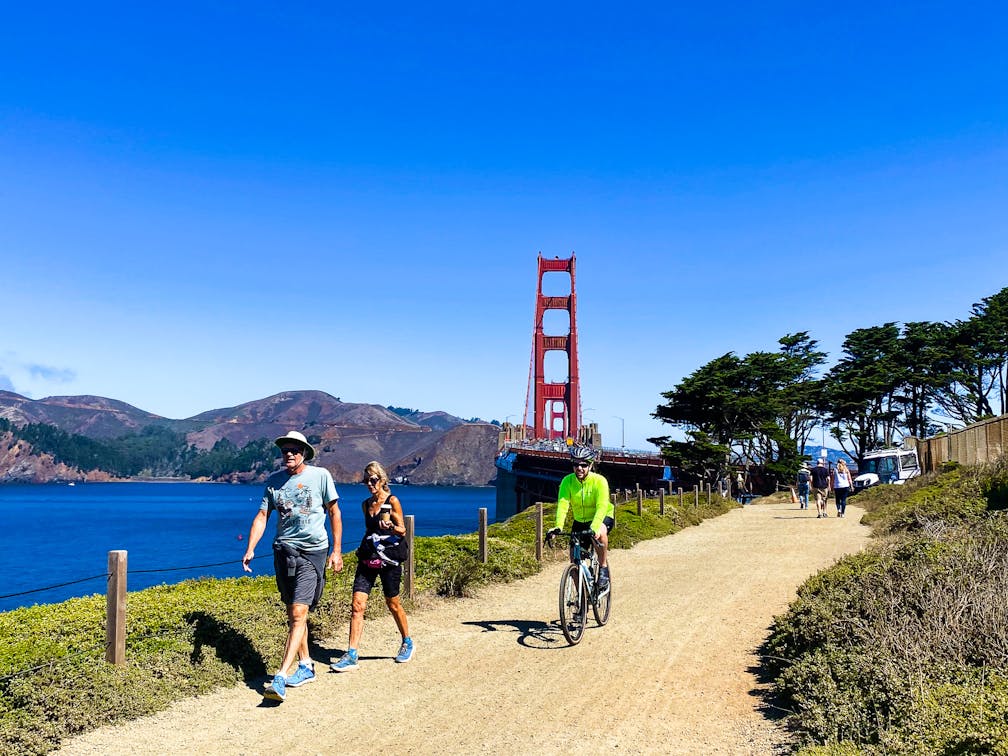
Bikers and walkers on the Bay Area Ridge Trail with the Golden Gate Bridge behind them

See San Francisco the way locals do by hiking the Presidio, a national park right in the city! Wooded trails, secluded beaches, and epic views of the Golden Gate Bridge feature on this 5.5-mile out-and-back on the Bay Area Ridge Trail. It’s a lovely slice of the City by the Bay.

Person in bare feet walking at Marshall Beach in San Francisco, with a view of the Golden Gate bridge

Marshall Beach in San Francisco with a northern view of the Golden Gate Bridge

Begin at the Arguello Boulevard park entrance. The Bay Area Ridge Trail begins beside the golf course, and immediately leads hikers into a lush eucalyptus and cypress forest. On the right, Andy Goldsworthy’s cypress art installation, The Spire, rises 100 feet into the sky, a symbol of the forest’s renewal and transformation.

Andy Goldworthy's cypress art installation The Spire in Presidio San Francisco

Follow signs for the Bay Area Ridge Trail as the route crosses Washington Boulevard. The path is lined with colorful (and edible!) wild blackberries and nasturtiums. Enjoy the beautiful splashes of gold, orange, red, and purple as the trail winds past Rob Hill Campground. This is one of only two campgrounds in the city. A quarter mile later, the trees thin to reveal the first view of the Pacific Ocean, along with the Golden Gate Bridge. Cross Lincoln Boulevard for a great selfie spot, then continue along the sandy path to the remains of the US Army batteries. These concrete structures were built at the turn of the 20th century to help defend the coastline.

Continue north along the Coastal Trail as it dips under the Golden Gate Bridge and emerges at a scenic viewpoint. To the northeast, Alcatraz Island and Angel Island can be seen in San Francisco Bay. To the southeast rises the downtown San Francisco skyline. And straight ahead to the north is the famed Golden Gate Bridge. Completed in 1937, the bridge connects San Francisco to Marin County. As the world’s longest and tallest suspension bridge at the time, it was seen as a symbol of American ingenuity and progress.

Detour briefly for a coffee and snack at the Round House Café. Those looking to dip their toes in the Pacific can hike back to the Batteries, and then turn right on the Batteries to Bluffs Trail, which adds 1 mile to the trip length. Follow the signs for Marshall’s Beach as they lead down a staircase path to the ocean. Often secluded, this beach is a local delight. Enjoy a water-level view of the bridge while picnicking on the wave-smoothed rocks.

Retrace your steps up the Batteries to Bluffs Trail and follow the Bay Area Ridge Trail back to the trailhead.

BONUS: Before leaving the Presidio, visitors with families will enjoy the new Presidio Tunnel Tops park. Relax at the Campfire Circle, play on the jungle gym, or grab a bite from local food trucks—all while surrounded by beautiful native gardens.

The Arguello Blvd. entrance is located at the intersection of Arguello Blvd. and Jackson St. in San Francisco. From I-280, exit onto CA-1 N. Continue onto Park Presidio, then turn right onto California St., then left onto Arguello Blvd. Continue into the park.The Presidio is free and open 24 hours a day. Dogs are not allowed on this section of the Bay Area Ridge Trail due to coyote activity.

Story and photos by Heather Werner, @heath.er.wer.ner

Trending Stories NorCal

View all Stories
  1. Field of Light at Sensorio in Paso Robles

    Light This Way

    Hidden in the bucolic hills of Paso Robles lies one of the greatest light shows on earth. The lighted art exhibition, Sensorio, is as if the rainbow magic of the aurora borealis was plucked from the sky and planted in the fields.

    View
  2. Surfboards and tents for shade are set up on the beach at Cull Canyon Regional Recreation Area in the Swim Lagoon Area

    Switchbacks and Swimming Holes

    Hike hard, play hard! This 7-mile out-and-back in Cull Canyon Regional Recreation Area is a great workout with payoff vistas and a relaxing post-hike picnic and dip in the water.

    View
  3. Hike the Rainbow

    Catch all the colors of a rainbow at Calero County Park on this 10-mile hike currently showcasing the season’s best blooms.

    View
  4. Hike Purisima Creek Open Space Preserve

    Purisima Charisma

    Hundred-foot redwoods, a shaded canyon, and views overlooking Half Moon Bay. This 10-mile loop hike in Purisima Creek Redwoods Open Space Preserve is a roller-coaster of uphill and downhill along with easygoing stretches through some of the Bay Area’s most beautiful landscape.

    View

Trending Stories SoCal

View all Stories
  1. People on a guided horseback tour with Central Coast Trailrides at Santa Margarita Ranch near Paso Robles

    Saddle Up with Central Coast Trailrides

    Untouched and sweeping, the mountainous scenery and deep valleys of Santa Margarita near Paso Robles are just begging to be explored. So saddle up for a scenic adventure with Central Coast Trailrides (CCT) at the 14,000-acre Santa Margarita Ranch.

    View
  2. A woman on a hiking trail with huge open space and yellow flowers around her at Wildwood Park in Thousand Oaks

    Going Wildwood

    Consider this your invitation to get a little untamed. In just one walk through Wildwood Park in Thousand Oaks, you can chase the sound of a cascading waterfall, duck into a shadowy cave, and soak in big hillside vistas. The mostly flat 4.25-mile loop makes wild feel wonderfully accessible.

    View
  3. Two people fly fishing on the Truckee River with guides from Reno Fly Shop

    Zen and the Art of Fly Fishing

    Learning to fly fish is one of the most fun and beautiful ways to connect with nature, family, friends, and yourself. It’s also a great way to truly experience the magic of a place. Make that place Reno Tahoe, where a fly fishing adventure with Reno Fly Shop is like being planted in a plein air painting of dreamy outdoors.

    View
  4. A woman on the overlook deck overlooking the Truckee River at Oxbow Nature Study Area in Reno

    This Way to Oxbow and Dickerson Road

    Just west of downtown Reno—tucked right alongside the Truckee River—is a nature haven for wildlife spotting and waterside relaxing. The 22-acre Oxbow Nature Study Area is ideal for those seeking solitude and a short hike. Afterwards, explore the creative hub of Dickerson Road.

    View