Haines Your Way

Hike Haines Canyon Debris Basin in the San Gabriels
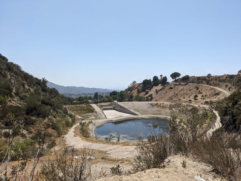
Haines Canyon Debris Basin in the San Gabriels Southern California

We all heart the superstar H2Os of the mountains—lakes, rivers, waterfalls, even man-made dams and reservoirs. But what about the unsung heroes of water management? Enter the debris basin, one of the less-visited, less-appreciated water features of the San Gabriels. See one on a 2.5-mile out-and-back hike (or mountain bike ride) that highlights the Haines Canyon Debris Basin, as well as some awesome valley views, and an optional route to the city’s highest point.

Hiker and dog on a trail in Haines Canyon Debris Basin in the San Gabriels Southern California

High point vista of Haines Canyon Debris Basin in the San Gabriels Southern California

Mountain Bikers on a trail in Haines Canyon Debris Basin in the San Gabriels Southern California

Park on the street at the north end of Haines Canyon Avenue and walk past the gate to reach the wide dirt trail. You’ll pass another Forest Service gate, and the Haines Canyon Debris Basin will be immediately on your right. Debris basins are specifically developed to capture any debris washed out of canyons by storms, including sediment, gravel, and local vegetation. Here at the bottom of Haines Canyon, this debris basin protects the surrounding area of Tujunga and beyond from floods, while allowing water to flow into the storm drain system. Because of that, the water level will vary depending on when you visit in relation to rains (and wow do we need some in SoCal!).

At the northeastern end of the debris basin, you’ll find a trail junction. Take a detour and head left up the steep incline; this is the Graveyard Truck Trail. Ultimately, it leads north almost all the way to Big Tujunga Canyon Road, passing the famous E.T. House along the way. At the top of the climb, check out the huge views of the San Fernando Valley. After enjoying the LA Kodak moment, head back down the way you came and continue along the fire road into the canyon, paralleling Haines Creek. 

As the trail gradually descends into the canyon, pass beautiful oak groves, mountain-bike spur trails, and 12 check dams (small constructions reducing water flow velocity). It’s picturesque throughout, with native riparian specimens dominating the trailside, including willows, sycamores, and cottonwoods. At the 1.25-mile mark (and about 600 feet in gain), you reach a T-junction. Both routes lead to Mount Lukens, the highest peak within the Los Angeles city limits (the more common route is via Deukmejian, which connects later on this trail), but if you’re here for the basin, this is a good spot to turn back unless you’re up for a big workout. Share the trail with mountain bikers as you head back to your car, and tip your hat to our new favorite flood-fending debris basin on the way out.

To get to the Haines Canyon Debris Basin and trailhead, exit Lowell Ave. off the I-210 and head north. After just over half a mile, turn left onto Foothill Ave. and after nearly a mile, turn right onto Haines Canyon Ave. You’ll have to make a quick right onto Day St. followed by a quick left to get back onto Haines Canyon Ave. After half a mile, you will reach the trailhead and street parking. Dog-friendly!

Story and photos by Matt Pawlik.

Trending Stories NorCal

View all Stories
  1. Sequoia Re-opens Crystal Cave

    Step inside Sequoia & Kings Canyon National Park's hidden world by visiting the newly re-opened Crystal Cave—the only cave in the parks open to the public. Closed for four years, this rare marble karst cavern is welcoming visitors once again, but only through the summer season!

    View
  2. Afternoon on the Island

    What is it about tiny islands in the middle of lakes? There’s something that just draws you in. It’s even more fun when getting there is half the adventure because you have to reach it by canoe, kayak, paddleboat, or a ranger-guided boat tour!

    View
  3. Easiest Best Hike in the World

    Choose the easiest and most view-rewarding hike in Yosemite. Okay, we’ll go first: the combination of hiking to Sentinel Dome and Taft Point. Both of these lookouts are within a couple miles of each other on Glacier Point Road

    View
  4. Hiker in the forest at Mount Sutro in San Francisco

    San Francisco's Middle Earth

    No need to travel to New Zealand to visit Middle Earth. San Francisco’s Mount Sutro Open Space is practically Hobbiton—a hidden “shire” in the middle of the city. Okay, maybe not quite as magical, but still an incredible place to take a hike in city limits.

    View

Trending Stories SoCal

View all Stories
  1. Locals' Feature: Jim Litchfield, Owner of Reno Fly Shop

    If there's a river, you're likely to find Jim Litchfield there. As the owner of Reno Fly Shop, Nevada's premier fly fishing outfitter and shop, Jim's passion for rivers knows no bounds: he's fished in places near and far, including Alaska, Bolivia and Christmas Island. But home is beautiful Reno, where he has been running Reno Fly Shop and leading tailored river float and fly fishing adventures (including beginner-friendly options) for over a decade.

    View
  2. Volcanic Activity

    Northern California is home to one of the most unique ecosystems in the country: Lassen Volcanic National Park. The region features geothermal areas, including the largest dome volcano in the world, Lassen Peak. Hike to the top of this active volcano on a 5-mile out-and-back.  

    View
  3. Great Is an Understatement!

    Tucked against the Utah border in eastern Nevada, Great Basin is a hiking wonderland of 13,000-foot peaks, ancient forests, sub-alpine lakes, and marbled limestone caves.

    View
  4. Lake Nacimiento
    Sponsored

    Savor Summer in Paso Robles

    Ready for the “Great California Road Trip”? Keep it real and rolling in bucolic and beautiful Paso Robles. This down- to-earth destination has everything you need to enjoy the coolest experiences.

    View