Hike the Dunes to the Beach

Hike Bodega Bay Sand Dunes to Salmon Creek Beach

Bodega Head is popular for its impressive cliff-hugging hiking trails, but few people follow the path north to a less-trodden hiking trail winding along the bluff and down to spectacular South Salmon Creek Beach.

To make this 4-mile (round-trip) journey from the Bodega Head parking lot, follow the trail north up along a dramatic bluffside until you reach a sign pointing the way to Salmon Creek Beach. You'll pass through the UC Davis Bodega Marine Reserve and across sand dunes covered in tall coastal grasses.

It’s likely you’ll have the trail all to yourself. After passing through the Marine Reserve, follow trail posts though sand dunes to the beach (a sign points to Salmon Creek Beach). Follow the trail until you reach a large resting area with picnic tables.

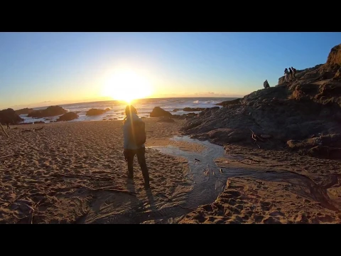
At this point, you’ll see a gently rising sand dune. You can’t see beyond it, so climb over it and descend to South Salmon Creek Beach (pretty much any nearby route you take at this point will deliver you to the beach). South Salmon Creek Beach is normally quiet this time of year, inhabited only by giant driftwood. Walk the dune-backed beach (just remember where you entered), or spread a blanket and relax for a while. Returning the way you came is equally rewarding, as the hike offers views of Tomales Bay.

BONUS: When you reach the trail sign to Horseshoe Cove (about a quater-mile from the parking lot), take the quick detour out to the rocky mounds overlooking the sea and the Marine Laboratory. Late day is the best time to be here to avoid major crowds and to witness the sun sinking into the horizon, brightening the ocean waves and coloring the clouds pink.

From Highway 1 in Bodega Bay, make a left on East Shore Rd. Go half a mile and turn right on West Shore Rd. Go another 3.5 miles to Bodega Head’s west parking lot. Take the signed trail north of the parking lot going up the bluffs. Return the way you came. No dogs.

Trending Stories NorCal

View all Stories
  1. Afternoon on the Island

    What is it about tiny islands in the middle of lakes? There’s something that just draws you in. It’s even more fun when getting there is half the adventure because you have to reach it by canoe, kayak, paddleboat, or a ranger-guided boat tour!

    View
  2. Hiker in the forest at Mount Sutro in San Francisco

    San Francisco's Middle Earth

    No need to travel to New Zealand to visit Middle Earth. San Francisco’s Mount Sutro Open Space is practically Hobbiton—a hidden “shire” in the middle of the city. Okay, maybe not quite as magical, but still an incredible place to take a hike in city limits.

    View
  3. A group of people clamored around the summit marker at Mission Peak in the Bay Area

    Your Mission Is Less Crowded

    Mission Peak is one of the Bay Area’s most popular mountains, with many hikers climbing every weekend. Skip the crowds with this 6-mile loop up the less-traveled southern route.

    View
  4. Hike top Angel Island Mount Livermore San Francisco Bay

    Good Heavens

    The 4-mile hike to the top of Angel Island offers Bay-mazing scenery. Some people claim you get a five-bridge view: Richmond-San Rafael, Bay, Golden Gate, San Mateo-Hayward, and Dumbarton bridges.

    View

Trending Stories SoCal

View all Stories
  1. Locals' Feature: Jim Litchfield, Owner of Reno Fly Shop

    If there's a river, you're likely to find Jim Litchfield there. As the owner of Reno Fly Shop, Nevada's premier fly fishing outfitter and shop, Jim's passion for rivers knows no bounds: he's fished in places near and far, including Alaska, Bolivia and Christmas Island. But home is beautiful Reno, where he has been running Reno Fly Shop and leading tailored river float and fly fishing adventures (including beginner-friendly options) for over a decade.

    View
  2. Bear Hug

    This 5.5-mile loop through Coyote Lake-Harvey Bear Ranch County Park explores one of the newest segments of the acclaimed Bay Area Ridge Trail, one redolent with trees ranging from madrone and manzanita to buckeye and blue elderberry (with a bubbly post-hike bonus).

    View
  3. Easiest Best Hike in the World

    Choose the easiest and most view-rewarding hike in Yosemite. Okay, we’ll go first: the combination of hiking to Sentinel Dome and Taft Point. Both of these lookouts are within a couple miles of each other on Glacier Point Road

    View
  4. Bikers and walkers on the Bay Area Ridge Trail with the Golden Gate Bridge behind them

    National Park City Walk

    See San Francisco the way locals do by hiking the Presidio, a national park right in the city! Wooded trails, secluded beaches, and epic views of the Golden Gate Bridge feature on this 5.5-mile out-and-back on the Bay Area Ridge Trail. It’s a lovely slice of the City by the Bay.

    View